


About an hour and a half due south of its famous neighbor Moab, (relatively) lightly-trafficked Bluff is a quiet yet fully-stocked base camp for several exceptional excursions doable in an easy and efficient flow. I’ve spent a good deal of time in this general area and was still astonished recently by the itinerary I’ll share here.
As ambitious a traveler as I tend to be, I’m not sure I’d try to pack all of this into a single dawn-to-dusk — although you might be able to, if you budget for a speeding ticket or two — but would instead recommend a gentler overnighter that still has you wrapped up within 24 total hours. So whether you’re coming in from Telluride, Moab, Lake Powell or (assuming a viciously early alarm clock) the Grand Canyon, any arrival that allows you to get started by midmorning will work.
VALLEY OF THE GODS, MOKI DUGWAY AND MULEY POINT
Eat a late breakfast, pack lunch and drive west half an hour on Route 191 (then 163) to our first stop, Valley of the Gods. While some might consider this area something of a “miniature Monument Valley,” a couple of hours among its stunning buttes and towering cliffs will convince you that its stark majesty is not merely derivative. The Valley’s 16 mile point-to-point dirt road is suitable for passenger cars and will deposit you at Route 261, where you’ll pause, breathe deeply and gather your wits for the next leg of your drive.
At the 261 junction, turn right and head up Moki Dugway. These serpentine switchbacks were carved by midcentury miners into the side of Cedar Mesa, and in three short, harrowing miles will lift you 1,200 feet above the valley floor. Granted, 11% grade is not especially extreme, and much of the road’s precarious feel owes primarily to its lack of asphalt and guardrails, so while it may not be one of the more thrilling drives in the world, it’s probably Top 20 in North America.
Incredibly, Moki Dugway is not why you’re here. At the top of the mesa, you may see the resumed pavement of 261 stretching out ahead and think, “Ah, civilization and safety…” and feel drawn toward the northeast. Nay, resist this primitive survival instinct and take your first left onto Muley Point (dirt) Road. After about ten minutes you’ll see a small campground, Muley Point East, with a teaser view beckoning beyond it. Keep driving until the road ends in another mile or so, at Muley Point. In recommending this “little detour,” my Red Rock Country Veteran parents had said that it afforded “a lovely view.” “Sure, we’ll try it since we’re over there anyway,” I agreed, entirely unprepared for what I’d encounter here, and still struggle to remember the last time a vista had caused me to gasp audibly as this one did. (Grand Canyon? Nope. Kehlsteinhaus? Nope. Empire State? Nope. Huayna Picchu? Maybe.) Standing just a dozen paces from your car and entirely unfettered by concrete walkways or chain link or the obligatory anti-Darwinian “Do Not Fall From Cliff” sign, you can simply turn your head to see Valley of the Gods to the east, Monument Valley to the south, and, with a downward cast to the foreground, the “gooseneck” cuts created across millennia by the San Juan River. This is why you’re here.
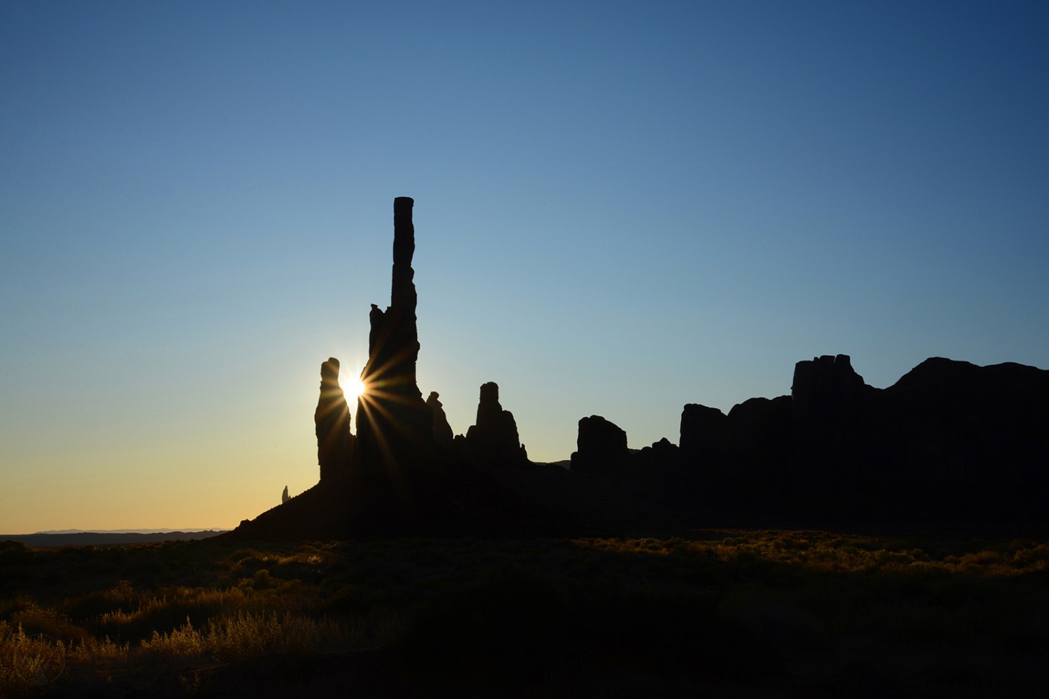
GOOSENECKS, MEXICAN HAT AND MONUMENT VALLEY
As a bonus, you get to downshift your way back down Moki Dugway, and when you arrive again at the Valley of the Gods turnout back on the valley floor, you’ll have devoted something close to two hours to the whole Moki-Muley leg. The sequence of what happens next as you head southwest on 261 will depend on the season and time of day, your preferences, and where you’ll be heading tomorrow after your visit to Bluff has ended. Whatever the circumstances, consider the following:
Half an hour down 261 (then 316) is Goosenecks State Park. The Goosenecks of the San Juan are a little tricky to describe. If you’ve been to Horseshoe Bend, picture more than half a dozen of those in succession; if not, remember the old-fashioned ribbon candies that grandma used as Christmas decorations year after year after year (i.e., the same pieces of candy) because nobody dared ingest them? Imagine pressing a few miles of that yuletide goodness a thousand feet deep into desert sandstone, then run a river at the bottom of the gorge. If that image still doesn’t work, then imagine, well, a bunch of goosenecks.
A couple of miles down 163 from its junction with 261 is Mexican Hat Rock, a 300-foot talus topped by a 60-foot, gravity-defying, disc-shaped rock that, with some imagination and a bit of squinting, resembles an aerodynamic sombrero on the small head of a man who faces southwest. Unless you want to explore the immediate environs, half an hour here should suffice.
Having read reams of reviews and recommendations, we opted for a sunrise tour of Monument Valley with Dineh Bekaya Tours, and couldn’t have been more pleased with our choice of the morning visit or the operator. After a predawn drive down from Bluff, we met our Navajo guide, Harry Nez, Jr., in the visitors’ center parking lot, piled into his Suburban, and he took care of the rest in expert fashion. He kept my drowsy boys engaged with ad hoc lessons on local history, teachings and traditions, pointed out specific shot locations of scenes in a long list of movies, and gave me exposure tips as I pointed my lenses toward the sunrise. Along 263 just northeast of Monument Valley you’ll drive the iconic Forrest Gump Hill. Take caution to avoid the jaywalking selfie-snappers, and then take a minute to join them.
Rather than bore and possibly insult you with a laborious iteration of every possible evening-morning itinerary involving these three, I’ll note that if it’s a choice between sunset at Mexican Hat or Goosenecks, and if you won’t be passing through this area again tomorrow (for example, en route back up to Bluff or Moab after sunrise at Monument Valley) and be able to see the Hat at that time, hit Mexican Hat first and then backtrack the short distance to the Goosenecks for the sunset. Also, sunrise at Monument Valley is otherworldly. I imagine sunset is equally glorious — maybe you could do that now, on your first night (rather than sunset at Goosenecks), as it’s a short distance from here. Tough call.
BLUFF FEATURES AND CREATURE COMFORTS
Back in town, you can imagine the travails of the 19th-century pioneers who tried to tame this land as you read their names (and learn their stories, if you stop at the fort) at the small hilltop cemetery, and you’ll also appreciate their efforts at refinement — not mere sustenance — as you look approvingly at their Victorian homes in the historic district. At the northwest edge of town, you may wonder how the Twin Rocks became not a national monument, as they would have almost anywhere east of the Mississippi, but instead the backdrop to a trading post and café.
Everything we ordered at Comb Ridge Eat and Drink was excellent: wood-fired pizza, the “Bad Breath Burger,” smoked bison short ribs, handmade cavatelli and chicken, etc. My two tweens even devoured an entire appropriately-named “Big Green Salad” each, such was its tastiness.
It takes quite a bit for lodging to exceed my expectations, and the only disappointment about our stay at the cozily-appointed Bluff Gardens Cabins was that it lasted just one night.
AREA EXTRAS WITHIN AN HOUR OR SO
- An hour east of Bluff, near the Colorado state line and Canyon of the Ancients National Monument, is Hovenweep National Monument, an “abandoned village” (hence its Ute name) once home to some 500 pre-Columbian Puebloans.
- An hour northwest of Bluff, State Route 95 (Utah’s “Bicentennial Highway,” for which the term scenic byway is a woefully gross understatement) passes by must-see Natural Bridges National Monument and directly over Fry Canyon, an often-muddy slot worth a stop and a clamber. Half an hour of hyperscenic driving beyond Fry you’ll watch the Colorado River enter Lake Powell, from the Hite Overlook.
- An hour north of Bluff in Monticello, turn left on 200 South and follow the Harts Draw Road up into the Douglas fir, Ponderosa pine and aspen of the Abajo Mountains, a range locals call “The Blues.” Check your odo when you leave Monticello and at just under ten miles pull off at the small paved lot to see Canyonlands and the La Sal Mountains through some handy fixed-focus, labeled viewfinders. At the junction just beyond this viewpoint, head due north toward Highway 211 and Newspaper Rock, one of America’s largest known petroglyph panels. Another hour north of Monticello, perhaps on your way to Moab, consider short out-and-back detours west of Highway 191 to the Big Spring Canyon and/or Needles Overlooks.
QUESTIONS FOR READERS
- How do some of your favorite vistas compare with Muley Point?
- What’s the most perilous road you’ve ever driven, other than the Jersey Turnpike?
- If you’ve been to Monument Valley for both sunrise and sunset, how do they compare?
- How many films can you name with scenes set in Monument Valley? (No googling!)
